Electronic intelligence from space has long been the business of intelligence agencies and the military. Miniaturized technology and Musk’s SpaceX company are now making this interesting for border agencies. Even radars from ships are to be scanned unnoticed by satellites.
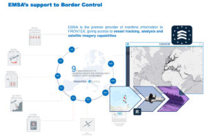
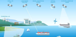
To locate and track vessels, Frontex uses Automatic Identification System (AIS) data, which requires every major ship to regularly transmit its identity, respective location and destination to receiving equipment via VHF radio frequencies. In this way, the border agency aims to prevent, for example, unwanted smuggling of refugees or even drug smuggling into Europe. The information is enriched with images from optical or radar-based satellites in an “overall situation picture.” Frontex uses an algorithm to determine from space data if a ship is behaving conspicuously.
The multilayered surveillance system reaches its limits when ships are “uncooperative” and turn off their AIS transponders. Images from high-resolution optical satellites are also expensive and can only be used during the day and in good weather. Synthetic aperture radar (SAR) satellite data can detect ships at all times, but their resolution is coarse.
Detection of radio transmitters and mobile phones
For this reason, Frontex is increasingly relying on the detection of electromagnetic radiation, such as that emitted by radios or cell phones on board of ships. This Signals Intelligence (SIGINT) or Geospatial Intelligence (GEOINT) has only been used by the military and intelligence services in recent decades. New miniaturized satellites and Elon Musk’s SpaceX company have now made the spy technology affordable for private contractors.

Titled “Detection of Satellite Radio Transmitters for Maritime Situational Awareness,” Frontex signed an initial €1.5 million framework contract with HawkEye 360 in 2019. The award to the American company was made without an otherwise standard European tender. After a market review, Frontex had said HawkEye 360 was the only company in the world with the technology at the time.
The company specializes in what is known as geospatial data analysis. As of 2018, HawkEye 360 was one of the first commercial providers to launch a series of small satellites capable of scanning the entire surface of the Earth for high-frequency signals. The transport was carried out by a Falcon9 from SpaceX.
Pattern recognition with Amazon
A year later, HawkEye 360 launched the first service called “RFGeo,” which graphically displays georeferenced data from electronic devices, making it easily accessible to customers.
The automated risk analysis of ships is carried out with the help of “artificial intelligence”, HawkEye 360 started a cooperation with Amazon’s ML Solutions Lab for this purpose. The aim is to uncover hidden patterns and relationships between ship characteristics. Potentially noticeable behaviors include fishing in restricted areas, ship-to-ship transfers on the high seas, and turning off transponders.
The Mediterranean is one of the first regions to be covered by “RF Geo” and the Border Agency was one of the first customers. In this way, the agency aimed to increase “situational awareness”, especially in maritime areas, but also over land areas.
Radiation of ship radars also of interest
The first framework contract was for a period of 365 days. A year later, Frontex announced a renewal, which it said cost €5 million and was also not put out to public tender. Presumably, however, the contract was once again awarded to HawkEye 360. However, Frontex is keeping details of this secret. Thus, it also remains unknown to what extent the SIGINT data from radios and transponders are actually used.

For its “situation analysis” Frontex had requested from HawkEye 360 access to four different data sources. These are radiations from VHF and X-band maritime radios, satellite phones, and AIS transponders. In its initial 2019 tender, Frontex already wanted electromagnetic emissions from ships’ radars to be processed as well.
However, HawkEye 360 did not officially launch such a service until 2020. It is therefore unclear whether Frontex has this capability.
Frontex knows of three companies with spy satellites
In its award decision to HawkEye 360, Frontex wrote in 2019 that there were two other companies that promised electromagnetic detection of ship radars in addition to electronic communications detection. However, it said these were “still in the initial stage of ramping up, i.e. satellites deployment and will reach full operational capabilities in the mid-term future only”.
One of the companies is French firm Unseenlabs, which has also launched several “space-based radio frequency detection systems” starting in 2019. Its customers include insurance companies, industrial groups and governments, according to the firm. Another manufacturer is Luxembourg-based Kleos, which also has offices in the UK. Its services are reportedly already being used in EU military missions, and intelligence agencies are also said to be using them. In the area of maritime security, the spy satellites are also suitable for border surveillance, Kleos writes.
Horizon Space Technologies has also entered the maritime satellite surveillance market with its Amber SIGINT CubeSats. The British company sells a similar system for manned and unmanned aircraft, which is sold to military and intelligence agencies worldwide. Horizon Space Technologies promises that each radar can also be assigned an invidual signature. However, the entire service will not be operational until the end of this year at the earliest.
EMSA monitors developments

The European Maritime Safety Agency (EMSA) also collects satellite data from various sources. It operates the CleanSeaNet, which creates its own space services and merges them with other information from Frontex. Regarding the detection and identification of ship radars using radio frequency detection, EMSA is more cautious than Frontex.
As a civilian technology, it is “still maturing as regards accuracy”, EU Transport Commissioner Adina Vălean wrote when asked. However, this is not a general rejection of spy satellites detecting ship radars. The Commissioner added that their “developments are followed”.
Image: CubeSats from Hawk Eye 360 (HawkEye 360).


Leave a Reply