In EUROSUR, EU member states use various satellite services for maritime surveillance. Frontex and the Maritime Security Agency conclude cooperation agreements with the “Copernicus” programme for this purpose.
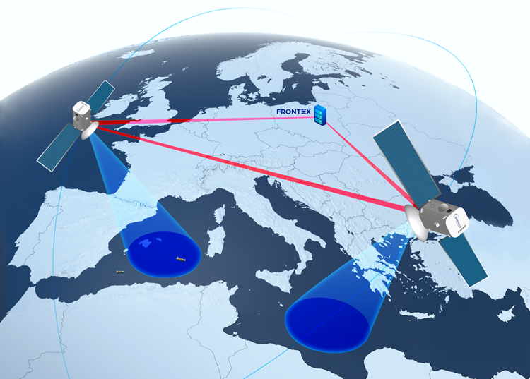
All the information Frontex collects at the EU’s external borders is fed into the EUROSUR border surveillance system, which went into operation in 2014. From space, this data comes from the satellites of the EU’s Copernicus Earth Observation Programme, which is used for security, civil protection, environmental management and climate change research. To date, the EU has launched several optical and radar-based reconnaissance satellites for the programme. The space data are received and processed by the EU Satellite Centre (SatCen) in Torrejón, Spain, which has the status of an agency.
In the first years of its existence, Copernicus was known as Global Monitoring for Environment and Security (GMES). After the European satellite navigation system “Galileo”, the European Commission described the platform as the “second flagship” of European space policy, tailored to increased security needs. While the purpose of GMES in public was emphasised to be the monitoring of climate change and natural resources, there was rather silence about the “S” for “security”. The first security-oriented GMES offshoots were LIMES (Land and Maritime Monitoring for Environment and Security), G-MOSAIC (GMES services for Management of Operations, Situation Awareness and Intelligence for regional Crises), MARISS (European Maritime Security Services), GMOSS (Global Monitoring for Security and Stability).
“Fusion services” from optical and radar-based satellites
Surveillance data from space is part of the “EUROSUR Fusion Services” (EFS) that Frontex offers to Member States. To this end, Frontex also requests national data, including from the French-Italian-Spanish-Belgian-Greek radar satellite-based system “Helios II” and the German “SAR-Lupe”. Suppliers of space data also include defence companies such as Leonardo and Airbus with images from their radar satellites. Optical satellite images are purchased by the border agency from commercial providers of the German GAF AG, which most recently received an order worth over €4 million.
For Earth observation for border surveillance, Frontex and the European Commission (represented by the Directorate-General for Internal Market, Industry, Entrepreneurship and SMEs) signed a delegation agreement in 2015, according to which the agency received a total of €47.6 million until 2021 for “integrated services” in the areas of security and border surveillance. For this, Frontex undertakes surveillance of coastal areas and the “pre-frontier area”, maritime surveillance, various means of vessel detection, tracking and reporting, and environmental monitoring. In 2018, “large-scale surveillance of the pre-frontier area”, “identification of places and activities of interest” (ProDetect) and “analytical assessment of migration” (MUSO) were added. Finally, on 15 November 2021, the Commission and Frontex signed the new agreement for “Copernicus”, which will run from 2022 to 2028. It includes an indicative budget of €67 million.
Frontex tracks “vessels of interest”
Little is known about the usefulness of Frontex’s space observation data. According to a 2017 final report of a joint test with the EU agencies EMSA (Maritime Safety) and EFCA (Fisheries Control), space-based reconnaissance data was generated and shared with member state coordination centres on 111 days. According to the report, ships and boats of eight metres or more in length could be detected with a high degree of reliability. In 33 cases, further measures were then taken by the coast guards there, and in 45 further cases, the EU military mission EUNAVFOR MED became active off Libya.
In 2020, the Frontex Fusion Centre delivered 409 optical and 1163 radar satellite images to the end users in the member states. This is said to have resulted in 94 “anomalies”. This refers, for example, to a conspicuous proximity to other vessels, a change of lane, a particular draught or transhipments on the high seas. In the same year, Frontex intercepted 110 “vessels of interest” and provided 92 reports. “Vessels of interest” can be tracked over a longer period of time – a “Maritime Simulation Module Service” based at EUROSUR makes predictions on their position. The information is passed on to the member states via an “Information Collection and Analysis Tool” (JORA) developed by Frontex.
Platform for “maritime analysis”
The analysis of satellite-based data is based on various sources. Frontex now uses a computer-based platform for “maritime analysis” for this purpose. To this end, the agency put a €2.6 million contract with the Israeli company Windward into regular operation in 2020. The company specialises in the digital aggregation and evaluation of ship tracking and maritime surveillance data and advertises with the slogan “catch the bad guys at sea”. Its investors include former CIA Director David Petraeus and former company heads of Thomson Reuters and British Petroleum.
The Windward platform is based on artificial intelligence techniques. Maritime reporting systems, including AIS position data from larger ships and weather data, are used for analysis. These are enriched with information about the ship owners and shipping companies as well as the history of previous ship movements. In this way, a signature is created for each observed ship, which can be checked for suspicious activities. If their captain switches off the AIS transponder, for example, the platform can recognise this as an anomaly and take over further observation on the basis of the recorded patterns. Windward uses the register of the International Maritime Organisation (IMO), which lists about 70,000 ships, as its database. Windward reportedly has additional information on a total of 400,000 watercraft, including smaller fishing boats. According to the company, its clients include the UN Security Council, which uses the technology to monitor sanctions, and the Italian Financial Police, which uses the system to monitor Italian territorial waters.
“Space Data Highway” from Airbus
Satellites orbiting the Earth can only transmit data to the ground within visual range, which considerably limits the functions of “Copernicus”, for example. Frontex therefore uses the European Data Relay Satellite System (EDRS) from the Airbus Group to ensure communication at all times. Three laser satellites of this “Space Data Highway” can establish a connection between lower-flying observation satellites and a ground station over distances of 80,000 kilometres. This allows their images to be transmitted almost in real time to anywhere on Earth. The system can also be used to transmit reconnaissance data from distant drones.
The “Space Data Highway” cost at least €520 million and is subsidised with large public sums as a public-private partnership between Airbus and the European Space Agency (ESA). Several countries are participating in the financing, including Germany, Italy, Switzerland, Luxembourg, Sweden, Belgium and the UK. The development of the laser terminals for receiving the data, located in Mecklenburg-Vorpommern, was supported by the German Aerospace Center (DLR), for example. However, the owner of the “Space Data Highway” is Airbus, so the company markets the services alone. Frontex was the first customer; in the meantime, the EDRS is also used by EMSA.
Satellite surveillance for EMSA and EUNAVFOR MED
With “CleanSeaNet”, EMSA also operates an earth monitoring programme; among other things, it is intended to detect oil spills and their polluters. For the use of “Copernicus” maritime surveillance, the agency, like Frontex, signed an agreement with the European Commission that provides for €73 million from 2021 to 2027. However, the core of EMSA’s satellite-based services is the provision of AIS data services for determining the position of ships. For this purpose, EMSA uses satellites that receive and transmit these signals. Around 34 million messages are generated in this way every day. In 17 cases last year, EMSA provided Member States with data from satellite monitoring for sea rescue purposes. Frontex and the Fisheries Control Agency EFCA also receive maritime surveillance information from EMSA. A new cooperation agreement allows members of the EU military mission EUNAVFOR MED to access EMSA maritime services to monitor maritime traffic in Libyan waters and ports.
In day-to-day operations, Frontex’s satellite-based maritime surveillance does not seem to be used to any great extent compared to the daily manned reconnaissance with the Frontex Aerial Surveillance Service . The reason for this is probably the low resolution of the sentinel data, which is five metres per pixel for radar satellites and ten metres for optical satellites. Commercial satellite data allow values of 30 centimetres, but require a corresponding budget. So presumably EUROSUR satellite services will continue to be used mainly for tracking suspicious larger vessels over several days and less for tracking small boats carrying refugees on their way to Europe. This could change when the EU has a new generation of high-resolution satellites or if Frontex receives even more money to use data from providers like Maxar for migration defence as well.
Image: Frontex.


Leave a Reply